Monuments
The Burren has been aptly described as one ‘vast memorial to bygone cultures’.
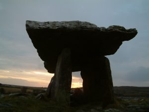
For instance, some 80 wedge tombs of Neolithic origin have been found in the region, from an estimated national total of just over 500. Hundreds of ancient cooking sites or fulachta fiadh and ancient cist graves are found throughout the hills. Some 500 ring forts are found in the Burren, including the magnificent triumvallate (three walled) Cahercummaun and the chevaux-de-frise (an ancient defensive structure composed of upright stones) ringed Ballykingvarga. Tower houses and Early Christian church sites are also very common, many in an excellent state of preservation. The magnificent portal tomb at Poulnabrone in the rocky heart of the Burren is one of the most easily recognised monuments in Ireland, but is only one very small piece of an extraordinary wealth of heritage to be found in the Burren.
Here you will find a listing of 9 of the main sites of archaeological and historical significance of the Burren. However, there are many more.
For further archaeological information try the following links:
Cahermore
Cahermore (‘big stone fort’) is a fine example of this most characteristic of Burren monuments. Over 500 stone forts are found in the Burren, many of them old farmsteads, but Cahermore is one of the most interesting and easily accessible. Recent restoration work has been conducted at the site, including the provision of interpretative panels, a wooden walkway and viewing platform, as well as the restoration of the original entrance. Located right by the R480 road between Leamanagh Castle and Ballyvaughan, Caherm ore is a short distance south of An Rath, an equally fine example of an earthen fort (known in Irish as rath) which is quite a rarity in the Burren, due to the paucity of available earthen material in the rocky landscape. An Rath has a very well developed canopy of trees, mainly mature beech, with a deep trench all around which occasionally fills with water. There are no parking or interpretative facilities at the site. This is under the management of OPW. Address: R480 rd, between Leamanagh Castle and Ballyvaughan
Caherconnell
The fort is in its original state. Its position, overlooking virtually all-surrounding areas suggests a defensive settlement. This may not have been defensive in a military sense, but rather for personal security from raiders or wild animals which were among the most common foes at the time. Ringforts such as Caherconnell are thought to have been inhabited from 400-1200A.D. However a description of the site at Caherconnell, in the early 20th century by local historian the late Dr. McNamara of Corofin Co. Clare suggests that the entrance to the fort may have been re-built in the 15th or 16th century. This suggests that this fort may have been inhabited up to the late medieval period. Address: R480 rd, between Leamanagh Castle and Ballyvaughan This is under private management but open to the public for a fee. Contact: [email protected] Tel: 065 6089999 website: caherconnell.com
Cahercommaun
One of the true wonders of the Burren, this dramatically situated ‘great fort’ is a little off the beaten track, but well worth the effort. Reminiscent of the famous Caher Dun Irghus on Inis Mor, Cahercummaun is a trivallate (three walled) fort precariously perched on the edge of a cliff overlooking a wooded valley. The entire site was excavated by a team from Harvard University in 1934, and a wealth of information is available as to the origins (built c.800AD) and use of this structure. Over 4,000 kg of animal bones were recovered from the site, of which an overwhelming 97% were cattle, indicating the importance of this site as a centre of farming activity, which is thought to have supported the 40 or so occupants of the fort. Located on the ‘back road’ between Kilnaboy and Carran, roadside parking is available for a few cars. Interpretative panels are located by the parking area, which leads to the site itself via a 1km stretch of undulating surfaced pathway, a lovely walk which traverses a number of species-rich habitats, from woodland to grassland to limestone pavement. Recent works at the fort itself have included the construction of a pathway and viewing platform. This is under the management of the OPW. Address: Between Kilnaboy and Carran.
Corcomroe
Corcomroe Abbey is one of the best-known monastic sites in Ireland. Built at the end of the 12th century by the Cistercians, or ‘white monks’, and occupied up until the 17th century, it became known as the Abbey of the fertile rock, a title that acknowledged the agricultural wealth of the surrounding Burren hills. The structure is under state care and is in an excellent state of preservation, with several fascinating and elaborate wall carvings, stone heads and tombstones still visible. Located close to the village of Bell Harbour in the north Burren, and linked to it by a secondary road, good parking facilities and an interpretative panel are available at the site. Impressive views of the surrounding hills are also visible from this highly recommended site. The graveyard surrounding the Abbey is still in use and so care must be taken not to disturb the site. This is under the management of the OPW. Address: Bellharbour
Dungaire Castle
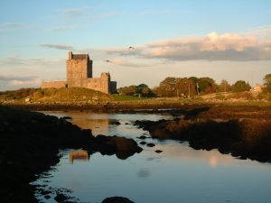
Dunguaire Castle is a small 17th century castle on a rocky promontory, situated just outside the picturesque village of Kinvara. The castle is an inspirational place, commanding the shores of Galway Bay and is famed in story and song. During the summer months Dunguaire Castle is open daily for visitors to explore, reservations are not necessary to visit during the day. There are also evening banquets and entertainment in the castle which require reservation. This is under the management of Shannon Heritage Tel +353 (0)61 711200 Web: www.shannonheritage.com
Gleninagh Castle
The main feature of this interesting coastal site is the imposing 16th century Towerhouse, once home to the O’Loughlin clan. The Tower is in excellent condition, and spectacularly located a short distance from the southern shores of Galway bay, in the shadow of the Burren hills. Nearby are found other interesting heritage features including a holy well, fulachta fiadh, earthen fort and the ruins of a medieval church. The site lies just north of the R477 road between Ballyvaughan and Fanore, and is accessed via a narrow roadway running from the main road. Parking and access are thus very restricted, and no other visitor facilities are available at the site. This is under the management of the OPW. Address: N of the R477 road between Ballyvaughan and Fanore
Kilfenora Cathedral
Located right in the heart of Kilfenora, just behind the Burren Centre, Kilfenora Cathederal was built in 1189 on the site of St. Fachtna’s monastery which was burned in 1055. Part of the building is still roofed and used for worship, while the remaining sections contain some extraordinary carved stone window frames and 13-14th century effigies. Three wonderful crosses are found nearby and to the west: a ‘Doorty’ cross and two richly decorated High Crosses. There is plenty of parking and other facilities in the vicinity, and the site has been recently restored. Well worth a visit. This is under the management of the OPW.
Kilmacduagh
A spectacular complex featuring an impressively intact Round Tower and several churches, Kilmacduagh is one of the most interesting and best-kept secrets in the Burren. Located just off the main road between Corofin and Gort (which lies just a few miles off) in the eastern Burren, the site has very good parking and interpretative facilities. There is a lot to see at the site, including elaborate stone carvings, impressive masonry (particularly in the soaringly symmetric round tower) and fine views of the eastern Burren lowlands. Ideal stop off as part of an alternative east Burren itinerary which would include Coole Park and Lough Bunny. This is under the management of the OPW. Address: Just off the main road between Corofin and Gort
Kilnaboy Church
This roadside church is located just west of Corofin on the R476 road to Kilfenora which loosely defines the southern boundary of the Burren. The 16th century structure has a number of notable features including a double-barred cross (referred to by some as a ‘cross of lorraine’) built into the gable end, a sheelagh-na-gig (pagan fertility symbol) over the southern door, and the ruins of an old round tower within the graveyard (which is still in use). A conveniently located lay-by is suitable for parking, though no other visitor facilities exist. This is under the management of the OPW. Address: West of Corofin on the R476 road to Kilfenora
Leamaneh Castle
Once home to the famous Maire Rua and, according to legend, location of her famed husband-killing exploits, this distinctive structure is composed of a Tower House built in 1490, with an extensive 17th century dwelling house attached. In the immediate vicinity of the castle are found an old bawn or enclosure, old fishponds and a deerpark. The building is inaccessible at the moment as ongoing restoration works are being carried out. The grounds of the castle lie on private property, but excellent views of the castle may be had from the roadside. It is situated at the intersection of the R476 Corofin-Kilnaboy road and the R480 road to Ballyvaughan, at the southern boundary of the Burren. There is limited parking space available on the roadside but care must be taken at this busy junction. No other facilities are available on site. This is under the management of the OPW. There is no access but it can be viewed from the road.
Newtown Castle
Defensively designed dwellings, Tower Houses or castles were built to meet the security needs of a period when cattle raiding by man and wolf was endemic, and an increasing military threat was being posed by the native Irish. There are twenty tower houses in Burren Barony, and fifty others in the adjoining baronies of Corocmroe and Inchiquin, though only ten survive to any height. Newtown castle is one of the best preserved and structurally interesting examples of Tower houses in the Burren. Part of the Burren College of Art complex, the castle is located close (southwest) to the village of Ballyvaughan, and affords quite spectacular views of Ballyvaughan valley and Ailwee mountain. Some parking is available at the site, though permission should be sought before visiting from the College staff. Address: Ballyvaughan www.burrencollege.ie
Parknibinna Wedge Tomb
Wedge tombs occur in a variety of sizes, locations and aggregations in the Burren, and though none have been excavated, it is thought that they generally date from the third millennium BC, i.e. the late Neolithic. At Parknabinna, in the south-east Burren, twelve wedge tombs are concentrated within a small area, with one particularly fine example conveniently located at the side of the back road between Kilnaboy and Carran. Just across the road is a wonderful glacial erratic, perched atop its limestone pedestal. There is very limited parking along the side of this narrow road, and no other visitor facilities are available here. The site is about 1km south of the entrance to Cahercummaun hill fort. Address: Between Kilnaboy and Carran
Poulawack Cairn
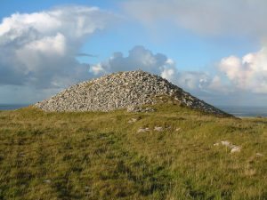
The multiple cist cairn at Poulawack in the south-central Burren is one of the best examples of the burial structure which succeeded the Megalithic tombs of the Neolithic. Excavated by a Harvard team in 1935, the remains of sixteen people interred in ten separate graves were found here, very few of which showed signs of cremation, indicating Bronze Age origin, a period when unburnt burials were quite common. Radiocarbon dating revealed that there were three main phases of activity: the mid-fourth, early second and late second millennia BC. As with many other Burren sites, there are scant visitor facilities available, even roadside parking spaces are very limited. It is located just west off the R480 road from Leameneh to Ballyvaughan. Much of the land in this area is private property so great care must be taken and the landowners wishes and rights must be respected. Contact: on private property contact landowner. Address: West off the R480 road – Leameneh to Ballyvaughan
Poulnabrone Portal Dolmen
Dated to c. 5,800 BP this is one of the oldest known structures in the Burren. Used as a burial tomb, when excavated it was found to contain the remains of up to 22 people, interred over six centuries. Evidence recovered from this site indicated that these people were farmers of cattle, sheep and goat, and that cereal was also grown. This is a site of international significance and renown, one of the most popular visitor attractions in the entire country. This has led to a degree of wear and tear at the site, which is currently undergoing a programme of works designed to accommodate the large visitor numbers while protecting the integrity of the site. No dedicated parking or interpretative facilities are available at the moment, but rangers are on hand to ensure the dolmen isn’t damaged, and may be able to help answer your questions. Address: Off the Ballyvaughan – Corofin road
More information on visiting the Burren region:
Towns & villages Nature Suggested itineraries Visitor Conservation – what can you do?

